Followers

Sunday, August 17, 2008

Microsoft sponsored 3D Conference in Hungary

International Conference on 3D data collection and modeling 

University of West Hungary Faculty of Geoinformatics, Székesfehérvár, Hungary, 27 August 2008

The following information was kindly provided by Prof. Dr. Márkus Béla of UWH Faculty of Geoinformatics :

In framework of UNIGIS  (www.unigis.hu) a one-week Summer School devoted to the topic „Urban 3D modelling” will be organised by UWH GEO (www.geo.info.hu) starting by 23 August. The course will be attended by 40 students from abroad and 10 from Hungary. For 27 August, a one-day conference has been arranged by the host organiser in order to give an overview on new methodologies in data collection and modeling in the field of the human settlements.  Issues addressed include advanced technologies in photogrammetry, and practical implementation of aerial laser scanning and 3D spatial visualisation. The venue is the UWH GEO's Knowledge Center on Land Management and Geoinformation.  Lectures will be delivered by some leading representatives of the 3D arena including top experts of Eurosense, LEICA, Varinex, Laservision/Riegl, YonaPMS, FIG Commission 7 as well as Prof. Franz Leberl, chief scientist of Microsoft' Virtual Earth program. The event has zero registration fee thanks to the prominent donor organisations. Major sponsor of the conference is Microsoft. Working language will be English. Details: www.geo.info.hu  HUNAGI advised the host and main organiser to offer one or more papers of the high-profile presentations for the International Journal of Digital Earth for publication. Also Editor-in-Chief Prof. John Genderen will be informed accordingly.

Program:


Earlier this year, Prof. Béla Márkus clearly indicates their interest to be involved in the implementation of the UNSDI and provided contribution via UNSDI HUCO related to the package "Capacity building"

Thursday, August 07, 2008

THEOS 1 ready for launch

More details at http://hunagi8.blogspot.com

Evaluation of some spatial data services in Hungary

Interviews within the eSDI-Net+ programme completed. Evaluated services include:
ZEGVATER Zalaegerszeg Municipality Asset Cadastre and Information System
VINGIS Vineyard Registry
PIR 
TeIR/TérPORT
MÉTA
KOMVIR 
More details will be given soon

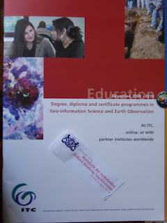
ITC Education Programme for 2009-2010

ITC Headquarters in Enschede, The Netherlands. Image: HUNAGI Visuals resource, 1999
From our daily mail.
Degree, diploma and certificate programmes in Geo-information Science and Earth Observation at ITC, Enschede
Details: www.itc.nl/education

Wednesday, July 23, 2008

Letters of Support and Recognition issued by prominent international organisations for HUNAGI

The  incoming Letter of Support of UNGIWG  - together with Letters of Recognition issued upon request by the European Umbrella Organisation for Geographic Information ( EUROGI), the Open Geospatial Consortium (OGC), the International Society for Digital Earth (ISDE) and the Global Spatial Data Infrastructure Association (GSDI) were attached to the proposal prepared by collaborators  in the subject "National Geospatial Technology Platform" submitted by HUNAGI to the grant authority on Monday, 21 July, 2008.Similar supportive document is expected from the SDI Unit of the DG JRC next week. Endorsed by HUNAGI, these letters will be circulated among the Platform Participants via the nominated NGTP Project Manager Attila Oláh.
In order to keep transparency, these letters are accessible for the wider spatial data interest community too:
EUROGI (European Umbrella Organisation for Geographic Information) 
Written by the Secretary General: www.fomi.hu/hunagi/pdf/2004/LoS-EUROGI.pdf
ISDE (International Society for Digital Earth) 
Written by the Secretary General: www.fomi.hu/hunagi/pdf/2004/LoS-ISDE.pdf
GSDI (Global Spatial Data Infrastructure Association) 
Written by the Executive Director: www.fomi.hu/hunagi/pdf/2004/LoS-GSDI.pdf
OGC (Open Geospatial Consortium) 
Written by the President and CEO: www.fomi.hu/hunagi/pdf/2004/LoS-OGC.pdf
UNGIWG (United Nations Geographic Information Working Group) 
Written by the Director of the Secretariat on behalf the Co-Chairs: www.fomi.hu/hunagi/pdf/2004/LoS-UNGIWG.pdf

These letters were issued to support the grant application of HUNAGI to establish and strengthen a National Geospatial Technology Platform in Hungary.
The abstract of the proposal written by Attila Oláh is as follows:

"National Geospatial Technology Platform

Proposer: HUNAGI (Hungarian Association for Geo-information)

Project duration: 24 months

Project budget: 36 000 000 HUF

Executive summary

The main goal of the project is to develop the Hungarian geospatial industry in a focused manner to enable it to enter the international technological arena. The proposer's main activities are to be expanded to handle the role of the nationwide framework platform for the National Spatial Data Infrastructure and related technologies.

During the 2 year lifespan of the project, a sustainable - 100% member funded - geospatial technological platform is to be developed. The project aims to have 4 courses of action: Research, Development, Innovation and Utilization."


Monday, July 21, 2008

HUNAGI signed the grant application on the establishment of a National Geospatial Technology Platform

Zsolt Barkóczi, President of HUNAGI duly signed the project proposal today. Images: HUNAGI Visuals resource, 2008

Participants of the event: Zsolt Barkóczi of HUNAGI, Attila Oláh of ESRI Hungary, Peter Gaertner, Tamás Martinák and Viktor Hajdú of the Consulting Company Brüsszel Center.

Officers of HUNAGI with the Managing Director of the Consulting Company Brüsszel Center.

Friday, July 18, 2008

GSDI President Bas Kok on the GSDI-11 at the ISPRS Congress

Prof Bas Kok in action. Image: HUNAGI Visuals resource, 2008
GSDI President Bas Kok co-chaired the second technical session of the ISPRS Working Group on Spatial Data Infrastructure during the ISPRS XXI Congress held in Beijing between 3-11 July 2008


On July 11, 2008 Prof. Bas Kok, President of GSDI Association co-chaired the first Technical Session of the ISPRS Working Group IV/1 on Spatial Data Infrastructures, arranged by Dr. Jie Jiang of the National Geomatics Center of China and Programme Organiser of the Congress.

Professor Kok also delivered an introduction to the 11th GSDI Conference during the second Technical Session of the Working Group on 11th July 2008. It was moderated by Gabor Remetey-Fülöpp of HUNAGI, and Secretary of the GSDI Association.

The session had four presenters including Prof.Chang-qing Zhu from China who gave an overview of the watermarking algorithm devoted to vector geospatial data. Toshimitsu Ishiwata from Japan introduced a data platform for promoting environmental management of coastal zones. The presentation of O.A.Ogundele of RECTAS in Nigeria generated considerable discussion and excellent contributions from Croatia, Nigeria, India and Iran. The subject of his paper dealt with the institutional development aspects of SDIs. He emphasized the prospects and challenges for the federal state in developing countries. His presentation was an excellent subject for the following presenter, namely Bas Kok, who addressed issues on the introduction of the evolution of global/regional/national SDI initiatives. These developments pinpoint the importance of capacity building, a top-down/bottom-up approach in legislation framework and institutional developments, as well as the importance of standards and frameworks to ensure interoperability.
The presentation was concluded with a film, offering message from the Dutch Ministry of Housing, Spatial Planning and the Environment highlighting the societal benefits from SDIs, and an invitation by the Mayor of Rotterdam to the next GSDI-11 Conference to be held in his city in June 2009.
Professor Bas Kok also participated in the meeting of the JBGIS Joint Board of Geospatial Information Societies, held during the ISPRS Congress in Beijing.
He also participated in a courtesy meeting hosted by the First Vice Premier of the Chinese Government, where a Beijing Declaration was signed.
As summarized by Congress Director Chen at the Closing Ceremony, according to this document, today we
„establish and operate a new „silk road“ for information from imagery, leading to people-centered and development-oriented information society.
- commit adequate investment and active engagement in scientific research and development, education and training as far as capacity and infrastructure building,
- promote the sharing of imagery technology and data for scientific research and peaceful applications,
- encourage constructive dialogue and close cooperation and collaboration between scientists, governments, public and private sectors , non-governmental organisations, and international organisations and institutions.“

Remetey-Fülöpp, Gábor (dr)
gabor.remetey@gmail.com

Report written for GSDI Newsletter. Published in the UNSDI HUCO newsblog by the kind permission of Ms. Karen Levoleger of the Dutch Kadastre, Assistant for GSDI President in the International Affairs. Her kind contribution is very much appreciated.

Thursday, July 17, 2008

The Beijing Declaration signed during the ISPRS Congress

Please find enclosed. Courtesy by GSDI President Bas Kok.
www.fomi.hu/hunagi/pdf/2004/Beijingdeclaration.pdf

Wednesday, July 09, 2008

Visit of the Remote Sensing Centre and Digital Earth of the Chinese Academy of Sciences


Short illustrated summary of the visit of the Disaster Situation Room and the Lunar Observation Control Room of the Remote Sensing Centre ad Digital Earth of the Chinese Academy of Science will be available here soon.

IJDE Editorial Board Meeting with invited ISDE Executive Committee members

Some of the outcomes of the meeting having also UNSDI relevance will be reported here asap.

Digital Earth Session at ISPRS Congress

Digital Asia, Virtual Australia: new trends in the implementation of the Digital Earth vision. More on the session with some references soon. 

Saturday, July 05, 2008

ISPRS Commission IV Discussion Meeting proposed to acknowledge UNSDI initiative


The inclusion of the UNSDI initiative in the context was suggested by HUNAGI representative for consideration and has been approved by the Open Discussion Forum chaired by the ISPRS Commission IV outgoing President Prof Shailesh on July 4. Image: HUNAGI Visuals resource, 2008
The Forum proposal for the WG IV/4 was Geospatial Data Cyber-infrastructure reflecting the role of the cyber/age and Internet-based services

Thursday, July 03, 2008

ISPRS Congress in Beijing

Photo taken on the projected slide. Image: HUNAGI Visuals resource, 2008 High profile presentations were given todaz by the candidate Presidents representing 13 bids for 8 posts this morning. Decision will be made later during the Congress by the General Assembly.

Tuesday, June 24, 2008

HUCO Newsblog attracts many top level entities worldwide


Statistics on todays' visitors were captured from the screen 
Service provider: ShinyStat

Raising the issue "NSDI and its Strategy should be emphasized in the National Strategy of Logistics

HUNAGI contribution to the closed shop Discussion Forum held yesterday by Governmental, Academic and Private Sector representatives on Strategies on Logistics as vehicle for the development of economy. The event was arranged by LEF, a platform of NGOs in  logistics.
HUNAGI was invited.
Report will be available soon.
Authentic source: www.mlbkt.hu
More on the event in Hungarian: http://hunagi8.blogspot.com

Thursday, June 19, 2008

UNSDI Stakeholder Meeting registered 15 UN Agencies and 15 Partner organisations

At UN COPUOS Meeting in Vienna UNGIWG Coordinator Mr. Suha Ulgen and Dr.Előd Both mentioned positively the efforts of UNSDI HUCO. 
Extract from the letter of Mr. Ulgen received today:
"Dear Dr. Remetey,
Thank you very much for conveying the statement of UNSDI HUCO in reference to the upcoming UNSDI Stakeholder Meeting in Geneva on 20 June 2008. We understand the reasons why you are unable to attend the meeting and very much appreciate the points you have raised in your statement which will be conveyed to the participants of the Stakeholder meeting.
I would like to take this opportunity to state that, earlier this week in Vienna, I had the pleasure of meeting Dr. Előd Both during the 51st Session of the Committee on the Peaceful Uses of Outer Space (COPUOS). I have shared with him my appreciation of your efforts to advocate for UNSDI which he acknowledged by a follow up statement he made during COPUOS deliberations. I am sure he will share his impressions of the exchange when he returns to Budapest.
Looking forward to our continued collaboration as we move the UNSDI agenda forward.
Warm regards,
T. Suha Ulgen (Mr.)
Coordinator - UN Geographic Information Working Group Secretariat (UNGIWG)
United Nations Office for the Coordination of Humanitarian Affairs (OCHA)
Geneva, Switzerland..."

Tuesday, June 17, 2008

HUCO Statement dedicated to the UNSDI Stakeholders Meeting scheduled for later this week

Geneva with Mont Blanc in the background. Image: HUNAGI Visuals resource, 2003
Recently, the UNSDI Hungarian Coordination Office released a statement dedicated to the UNSDI Stakeholders Meeting hosted by the UNGIWG Secretariat in Geneva, Switzerland. The statement is publicly available Please click on the header  

Sunday, June 15, 2008

Digital Earth Summit 2008 in Potsdam

Einstein Tower in Potsdam Image: HUNAGI Visuals resource, 2001
ISDE Summit on Geoinformatics as tool for Global Changes 
hosted by the German Geoscience Research Center, Potsdam
12-14 November, 2008

To arrange early registration please download the official leaflet of the event at
 http://www.isde-summit-2008.org/upload/pdf/Flyer_ISDE08.pdf

Thursday, June 12, 2008

Prime stakeholders's consultation on UNSDI

Representatives of MoEW, FÖMI and HUCO at a consultation hosted by Dr. Szabolcs Mihály (m) this morning. Image: Judit Szabó for HUNAGI Visuals resource, 2008
The goal of the consultation was to identify the major aspects related to the HUCO  statement to be sent for UNGIWG before 16th June 

Wednesday, June 11, 2008

Spirit of PSI to be applied in Geographical names

Participants of the first Thematic HUNAGI Talks. Image: HUNAGI Visuals resource, 2008


Geographic names and 
e-Content services
 
The high profile meeting hosted by the National Digital Data Archive (NDDA) on 11 June was attended by leading representatives of the Hungarian Content Industry Federation (MATISZ), the Hungarian Committee on Geographical Names, and the hungarian Association for Geo-information.
Initiated by the Neumann Non-profit Company's  NDDA programme, the participants of the first Thematic HUNAGI Talks devoted to the subject were invited by HUNAGI. 

Summary will come asap

Tuesday, June 10, 2008

Hungarian Standards Institute Technical Commission 818 on Geoinformatics

Some of the participants in the Ybl Room of the HSI HQ. Image: HUNAGI Visuals resource, 2008
Meeting of the TC 818 'Geoinformatics' of the Hungarian Standards Institute
Hosted by Secretary Gábor Varga of HSI/TC818 and chaired by its President Dr. Szabolcs Mihály,  the Commission had a rich agenda today covering the recent activities of the CEN/TC 287 and ISO TC 211 as well as the action plan for 2008. 
Hungary is P Member of ISO/TC 211 since March 5, 2008. The upgrade was initiated by András Osskó and Gyula Iván, Chair and Vice-Chair of  the FIG Commission 7 elaborating the Land Administration Domain Model. HUNAGI representative welcome this upgrade and urged the importance of similar membership of a Hungarian university in OGC in order to enable access for information might be useful for some dedicated tasks to be performed in Hungary. The ongoing Hungarian activities are related to the adoption of EN ISO 19128, 19131 and 19137.
Fortunately, all of the HSI/TC818 actors are members of HUNAGI and belongs to stakeholder institutions of UNSDI HUCO.
The 2nd Conference of CEN/TC287 started today at FAO HQ was shortly mentioned emphasizing the opportunities for the  Hungarian Standards Institute if the  'clone'  subregional CEN/TC 287 Conference will be decided to be hosted by Budapest in six months.
The subject will be discussed by HUNAGI Presidential Board asap, by the participation of the  President of  HSI/TC 818.  

Monday, June 09, 2008

National IYPE Committee Meeting hosted by the Hungarian Academy of Sciences

The Presidential Council Room of HAS, venue of the meeting. Image: HUNAGI Visuals resource, 2008
Next action under IYPE aegis: HUNGEO in late  August in Budapest hosted by the Eötvös L. University of Sciences (ELTE).
Chaired by Károly Brezsnyánszky, former Director of the Hungarian  Geological Institute, the National Committee on the International Year of the Planet Earth met Monday afternoon. Agenda topics included the evaluation of the highly successful Opening Event attracted over 6500 visitors in April and the overview of the follow-on actions with special emphasis on the IYPE-related  domestic series of events.
HUNAGI representative made two proposals (related to the ISDE Summit in Potsdam and the planned FAO/CEN Conference in Budapest) for consideration which were supported by the Committee.

GEOSS Common Infrastructure

According to the circular letter sent by GEO Secretariat Director José Achache to the GEO Member States and Participating Organisations recently, the evaluation phase of the GEOSS Common Infrastructure has been launched by three actions requested from the side of the GEOSS community:

- Evaluating the GEO Portal candidates,

- To register components such as data bases, catalogues, services and tools in the GEOSS Components and Services Registry, as well as

- To register standards, protocols and other specifications enabling the interoperability of components in the GEOSS Registry.

The three GEO portal candidates are as follow:

Friday, June 06, 2008

Tuesday, June 03, 2008

UNGIWG Meeting devoted to UNSDI in Geneva


UNSDI HUCO was invited to attend the Meeting by the Co-Chairs. The internal UN document to be discussed will be circulated among the Steering Committee members of the Hungarian UNSDI Coordination Office and a fourth meeting of the Steering Committee is foreseen before 16th June, the deadline for feedback to the UNGIWG Secretariat in Geneva.

Saturday, May 31, 2008

HUCO blogsitee was visited from 67 countries in this month

Number of visitors in May 2008:   358 
Breakdown by countries:
 Hungary21.55 %
 United States of America17.13 %
 Italy6.63 %
 United Kingdom5.52 %
 Spain3.87 %
 Other   45.30 %                                
Number of  visitors linked from another URL:   91

FAO launched website on Climate Change

As Jelle U. Hielkema raised the attention of the NCOs in a circular message today, the new website of FAO devoted to Climate Change has the following URL:

Forthcoming events listed in the website include conferences on topics
Food security and poverty reduction in the face of climate change and energy security, FAO, Rome, 3-5 June, 2008
Climate change and the cost of mitigation and price for inaction OECD Paris, 3-5 June, 2008, as well as 
Climate change and forestry management (Umea, Sweden, late August)

Thursday, May 29, 2008

Success of the Hungarian Digital Cadastre - Conference hosted by MoARD

Gyula Biró, Director General of Geodezia Shareholding Company delivered lecture on the role of the private sector in the process. Image: HUNAGI Visuals resource, 2008
A Press Conference was held on the topics Digital Cadastral Maps and e-Land Offices by Assistant Deputy State Secretary Ferenc Sirman of the Ministry of Agriculture and Rural Development, Sándor Simon, Director of  the National Cadastral Programme Non-profit Public Benefit Company as well as dr. Szabolcs Mihály, President of the Hungarian Society of Surveying, Mapping and Remote Sensing
CADASTRAL MAPS OF THE 21ST CENTURY
CONFERENCE PROGRAM


29 May 2008 MoARD

10.05 - 10.20 Opening Address

Gráf, József Minister, MoARD

10.20 – 10.35 State of the art of the National Land Fund and its role in the land tenure policy

Benedek, Fülöp  Deputy Director General, Agraian portfolio, MNV Zrt.

10.35 – 10.50 Implementation strategy of the digital Land Offices

Sirman, Ferenc Assistant Deputy State Secretary, MoARD

10.50 – 11.05  The role of the location in the Information Society

Dr. Detrekői ,Ákos academician, Chair of the National Council for Informatics and Communication

11.30 – 11.45 The role of the digital maps for the land and property registry

Horváth, Gábor Director General, MoARD

11.45 – 12.00 Digital processing of the cadastral maps of Hungary in the framework of the National Cadastral Programme

Simon, Sándor Director, NKP Kht.

12.00 – 12.15 Paradigma change in data policy in light of the digital data service

Dr. Mihály, Szabolcs, Director General of FÖMI, President of the Hung. Soc of Surv. Mapp. and Remote Sensing

12.15 – 12.30 National Cadastral Programme a half-time flashback

Tóth, Sándor  Deputy Director General, MoARD

13.40 – 14.00 Our cadastral maps in international comparison

Osskó, András, Chair, FIG Commission 7 Cadastre

14.00-14.20  Importance of vocational training in projects in the surveying

Dr. Szepes, András Deputy Dean, Faculty Geoinformatics, West Hungary University 

14.20-14.40 A historical overview of the digital maps and systems of the Capital.

Szilvay, Gergely Head of Department of Surveying, Budapest Land Office

14.40-15.00 Experiences with the digital maps n the Land Offices of the County Szabolcs-Szatmár-Bereg

Oros, László Head of the County Land Office SzSzB

15.20-15.40 The Hungarian Digital Orthophoto Program (MADOP) and the renewal of the vectorized maps f te outskirts

Peter, Winkler, Advisor of the Director General, FÖMI

15.40 – 16.00 Adatszolgáltatási lehetőségek a digitális adatállományokból

Dr. Vass, Tamás Head of  Department, FÖMI

16.00-16.20 Service of the cadastral map data on TAKARNET network

Weninger, Zoltán Head of Department, FÖMI

16.20-16.40 Role of the enterpreneurs in the acceleration of the National Cadastral Programme

Biró, Gyula Director General GT Zrt, President of the Hung Society of  Enterpreneurs in Surveying and Geoinformatics

30 May 2008 FÖMI HQ.

9.00-9.20 Work completed but only for the first phase!

Bartos, Ferenc Deputy Director, NKP Kht.

9.20-9.40 Experiences with  data service of extensive areas

Dr. Váczy, Attila theme leader, NKP Kht.

9.40-10.00 The role of cadastral maps in the Agricultural Land Parcell MePAR service

Forner, Miklós counsellor, FÖMI

10.00-10.20 Digital Cadastral Map based urban management system in Zalaegerszeg

Takács, Ferenc, Head of Section Informaticső, Zalaegerszeg County Level Municipality

Purger, Zoltán Head of the Dept of Surveying, Zala County Land Office 


Members of the Umbrella GI Association HUNAGI are highlighted with bold characters.

Courtesy translation by RFG, not an official version!

Source: http://www.fvm.hu/main.php?folderID=1227&articleID=12658&ctag=articlelist&iid=1


Friday, May 23, 2008

ISPRS Hungarian National Committee Meeting

Chaired by Miklós Gross, the new composition of the ISPRS Hungarian National Committee was nominated and discussed at a meeting hosted by the Institute of Geodesy, Cartography and Remote Sensing this morning. New board includes the Chair (Miklós Gross of EUROSENSE Ltd), Secretary (Gergő Maucha of FÖMI RSC) the National Correspondents assigned to the 8 Technical Commissions of ISPRS as well as about 10 invited members including experts coming from academia, private sector and NGO such as HUNAGI. The list will be announced if the ExCom of the supervisory MFTTT will approve the nominees.
Miklós Gross, Chair (rightmost) and the participants of the meeting. Image: HUNAGI Visuals resource, 2008

Contributing to the activities of the ISPRS HNC, HUNAGI SG circulated a short survey with requested feedback and expressed interest to take part of the planned UN Workshop to be held in Budapest in October, to contribute to the HUNAGI presentation a the ISPRS Congress, to take part in the eSDI-Net+ related evaluation methodology actions, as well as to publish in international media e.g. GIM ( the Global Magazine for Geomatics),
Geo: (Geoconnexion International Magazine), IJSDIR (International Journal of Spatial Data Infrastructures Research) and IJDE (International Journal of Digital Earth).

Tuesday, May 20, 2008

Newsletter of the UNSDI National Office of The Netherlands

By the courtesy of Mr. Jan Cees Venema, Head of the UNSDI NCO in The Netherlands, please find below the second issue of the Newsletter of our Sister NCO just received:

2008 - Issue 2

Dear Gabor Remetey,

In this issue:

  • Status UNGIWG/UNSDI developments
  • UNSDI activities in the Netherlands
  • GeoNetwork graduates from OSGeo incubation
  • 2nd Mediterranean Workshop Rome 10-11 June 2008

New subscriptions can be made at the www.unsdi.nl/news page. So if you have colleagues or know any other interested parties, this is the place for them to go.

Jan Cees Venema


Status UNGIWG/UNSDI developments

On 5 & 6 February 2008 the UNGIWG Secretariat organized a workshop, hosted by WFP in Rome in order to formulate the so called "UNSDI Deliverables", being data sets which the UNGIWG members consider to be the "core geo-data sets" for an initial UNSDI, needed by the UN bodies as a comon baseline for their work. Additional deliverables identified are capacity building activities, both within the UN bodies as in developing countries, the latter being dubbed "indigenous capacity building". Other Deliverables are on interoperability and tools.

In March/April the Interim UNSDI Deliverables List and 1st draft of the UNSDI Framework Project Document were finalized and circulated to the members for comments. For the rest of the year the following major milestones are foreseen: in May/June the Interim UNSDI Board and the Interim Technical Advisory Body (TAG) will be established. In July the UNSDI Project will be established with UNOPS and the UNSDI Project Team will be formed. In early November, at the UNGIWG-9 meeting, hosted by UNOOSA in Vienna, the UNSDI Board and TAG will be formed and the UNSDI Project Team recognized. In December the UNSDI Project and the Deliverables List will be adopted by the UNSDI Board.

Next steps are to:

  • Finalize the Deliverables, work plans, budgets, issue donor appeal document
  • Set-up UNSDI structures: institutional and technical
  • Dialogue with major external stakeholders (UN reform bodies, governments, etc.)
  • Mobilize resources
  • Sustain UNGIWG Secretariat, set-up UNSDI Project Team

Here you can find the new UNSDI Technical Governance Framework documents:

More documents at http://www.ungiwg.org/documents.htm.


UNSDI activities in the Netherlands

The Netherlands Coordination Office (NCO) of UNSDI assisted the UNGIWG-UNSDI members with the formulation of the “UNSDI Deliverables”, in particular the translation of functional requirements into products and services, assisted by UNSDI-NCO partners the International Institute for Geo-Information Science and Earth Observation (ITC) and SarVision on the issues of indigenous capacity building and land cover mapping in tropical regions respectively.

The Netherlands' Permanent Representative to FAO, WFP and IFAD, Mrs. Agnes van Ardenne, forwarded a comprehensive note concerning possible participation in UNSDI and FAO SDI development to the Netherlands' Government. The note, which was prepared with inputs rom FAO and the NCO, is presently being processed by the Ministry of Foreign Affairs, the Ministry of Housing, Spatial Planning and the Environment and the Ministry of Agriculture, Nature and Food Quality, since UNSDI covers relevant MDGs, environmental protection, food security, humanitarian response, economic development and peace and safety issues. UNSDI-NCO is providing the necessary input in this process.

Our National UNSDI-NCO GeoNetwork portal (www.geonetwork.nl) is now operational for almost a year and contains over 17.800 database items. In this period some 6880 geo-information downloads have taken place by users from 117 countries! The portal is still powered by GeoNetwork 2.0.3, but will be upgraded to version 2.2.0 in the second half of this year and will have it's full functionality by then.


GeoNetwork graduates from OSGeo incubation

Over the past year the GeoNetwork team, led by Jeroen Ticheler, worked on making GeoNetwork opensource a full OSGeo project. A few weeks ago GeoNetwork was vetted by the OSGeo board as 'graduated' from the OSGeo incubation process. This makes GeoNetwork an official OSGeo project and should help to ensure the long-term sustainability of the project. Congratulations Jeroen and team!

Jeroen recently wrote an article that has been published in the May issue of Geoconnexion International magazine as part of a series on OSGeo columns on open source geospatial software. The link to the article online: http://www.geoconnexion.com/uploads/opensource_intv7i5.pdf.


2nd Mediterranean Workshop Rome 10-11 June 2008

On 10-11 June 2008 FAO will host an important event on climate change issues and spatial data infrastructure: the 2nd Mediterranean workshop. The workshop is held under the aegis of the European Standardization Committee for Geographic Information, CEN/TC 287. Day chair will be Prof. Arnold Bregt (Wageningen University and Research Center). It is the second of a series of Mediterranean Workshops, the first of which was held in Athens on 14 March.

Full information about the workshop, including its programme, registration and logistics details can be found on this website http://www.gistandards.eu

The workshop will bring together a wide variety of experts, representing geographic information standards, SDI, interoperability, ontologies and applications. On both days the programme features an excellent keynote speaker and moreover the Chair of ISO/TC 211 will participate in the workshop. Participation in the meeting, which will be held in FAO's Green Room with ample seating capacity, is free of charge and on the evening of the first day a reception will be offered on the FAO Terrace overlooking ancient Rome.

If it fits your agenda you are all encouraged to come to Rome for this event which is occurring at an important point in time in, among others, the UNSDI development process. Furthermore the workshop is being held immediately following the global food security, climate and bioenergy conference the week before and about which full details in this link http://www.fao.org/foodclimate/

The registration is now open for the workshop. More information will be added to the site but you can see the full agenda and register now. The agenda speaks for itself, the high calibre speakers working towards harmonisation will make this a most educational and productive workshop.

Due to the high interest received for this event we urge you to register as early as possible. Without registration, entry to the workshop will not be possible. Please make sure you register as soon as possible.


You are subscribed to the UNSDI-NCO Newsletter. To unsubscribe click here
More news and subscriptions at the UNSDI-NCO website or use the RSS feed

"